
Photo Gallery: May 3rd Kitsap Thunderstorm
As Kitsap gets sidelined by a nighttime thunderstorm, many flock outside to watch and capture lightning.
Captures of the lightning taken in the Bangor Base area.
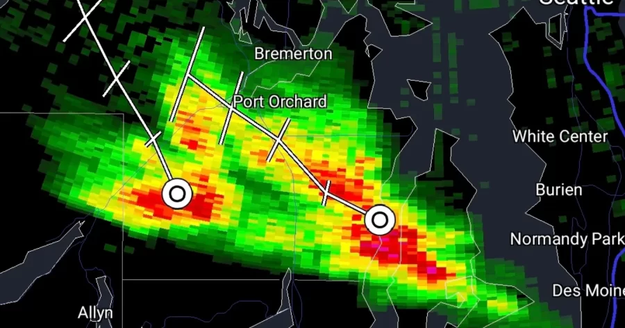
On the evening hours of May 3rd, a cell was spotted over Federal Way by the National Weather Service in Seattle/Tacoma.
The cell was observed to be producing localized downpours across the lower Puget Sound but nothing much more than that.
As the cell entered the areas of Tacoma and Bainbridge Island convection intensified.
The cell began to get larger causing its top to stretch higher into the sky as it moved to the Northwest.
Its first lightning strikes were observed in Tacoma as it slowly moved through the area, with instances of cloud to ground lightning strikes making themselves known.
The now thunderstorm, while rare for Washington State, wasn’t particularly significant as it sporadically showed its many spectators some lightning strikes. This was before it moved into the Kitsap area.
The storm would further intensify, topping out at 37,000 feet, much higher than what is normal for the Puget Sound. The towering clouds could be seen by virtually anyone in the Puget Sound.
As the storm continued, and the sun set, the amount of lightning it began to produce dramatically increased.
Those who were caught under the storm were greeted to a mix of downpours and thunder. Those caught on the outskirts though, were treated to a spectacular lightning show.
Bangor Base, for example, would be caught on the Southern side of the powerful storm, which would lead to a number of lightning captures by residents.
During thunder and lightning storms, it is best to find shelter. Follow these safety tips from the CDC to stay out of danger.